Roman roads
Since the very beginning of the Republican era,construction of roads had been an imperative task in Rome. In the 4th century BC,Rome extended its power to northern and partly central regions of the Apennine Peninsula. However,fertile Italian south was still out of reach. In the study of life and achievements of Appius Claudius Caecus,L.P. Kucherenko states that relations with Campania were not stable and depended on Romans’ military success in this part of Italy. This was a trigger for the Roman urge to build stone or paved roads in order to send military troops to the remote areas. F.F. Velizhsky believes that the Romans built the roads that maintained commercial and moral relations with Rome,the center of the empire. The fact that roads contributed to improvement of economic liaison between regions is also supported by R. Laurens,who argues that urban and agricultural development was improving simultaneously with development of the road infrastructure in Italy. That period also witnessed expansion of large land estates owned by the Roman elite and located remotely from Rome. It proves the idea that complex and far-reaching road network contributed to the rise in economy and trade. Moreover,we can refer to the ancient authors who wrote about using the roads,for instance,Horatius in the Satires: “We took this lazily in two days,though keener travelers than us take only one: the Appian’s easier taken slow!”. Also,Cicero in his letters writes about taking the Appian Way: “for I had intended to go straight on by the Appian way to Rome.” It proves that the roads were often used by private persons. It is worth noting that the Roman Empire had a courier service,Cursus Publicus,which delivered messages from the emperor to governing officials and military leaders in the provinces. This service covered the whole Empire; and the right to use the public service was certified by the permits called “diploma” and issued by the head of state. Pliny the Younger in his letters to Trajan asked: “I beg you,Sir,to write and tell me whether you wish the permits,the terms of which have expired,to be recognized as valid,and for how long.” Trajan replied: “The permits,of which the terms have expired,ought not to be recognized,and consequently I make it my special duty to send out new permits to all the provinces before the day when they are required.” However,despite the above-mentioned,the primary goal of road construction was military. L. Thompson believes that roads along which the Roman legionaries marched served as an important factor for the Roman army mobility. Usual earth-bed or country roads could not ensure quick movement of legionnaires,especially in rainy weather when the roads were washed out. These were the reasons why in the 4th century BC,stone roads construction began. Construction of roads,like general urban planning,was supervised by censors. Titus Livius mentioned that the Senate financed construction projects by issuing construction loans to the censors; also,the censors had public funds to commence construction. When the money was paid,the works were not specified,and the censors could decide at their own discretion how to spend the money - to construct new facilities or repair the old ones. Paved roads were built by soldiers or slaves. The first records of construction principles for the Roman roads can be found in the set of ancient Roman laws called “Law of the Twelve Tables”,dating from 451-450 BC. Table VII states: “The width of a road shall be eight feet on a straight stretch,on a bend sixteen feet”. However,with time this regulation was not strictly followed. O. Choisy wrote in “History of Architecture” that since the 4th century BC,when the roads had strategic importance,they had been built in a straight line,where possible,with no branches to intermediate areas. Occasional deviations from the straight line were only allowed to avoid climbs. The paved part of the road was used for urgent communications; and since Roman horses were not shoed,wide side with natural soil on the right and left were used for common traffic. Roman builders planned routes of their roads so carefully that some modern highways now run along the ancient paths (e.g.,the road section between Londinium and Verulamium is now modern Watling Street,running from Dover to Wroxeter).
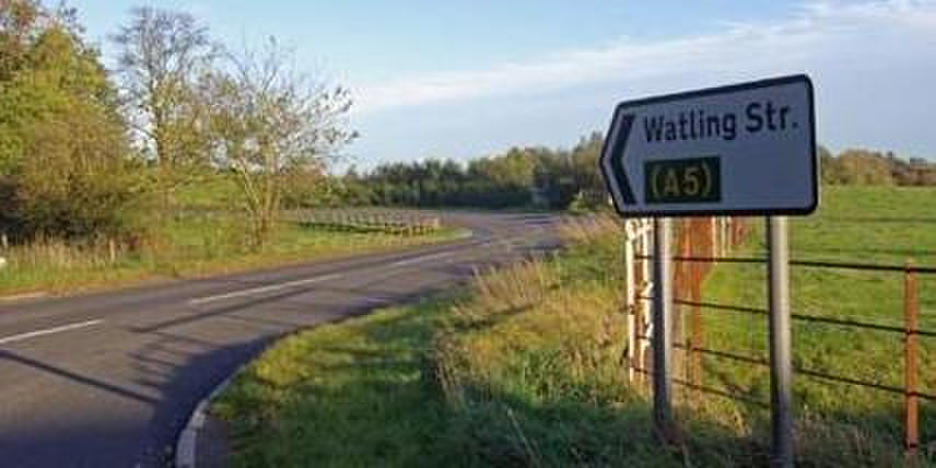 Modern view of Watling Street between Dover and Wrockster, laid out on the site of the Roman road between Londinium and Verulamium.
Now,Italian highways are often built on a parallel track with the ancient roads. The most vivid example is the highway from Rome to Naples,some sections of which go parallel and in close vicinity to the Appian Way. The latter was the first strategic road build with a view of conquering southern Italy. It was named after the censor Appius Claudius Caecus,who initiated construction in 312 BC. L.P. Kucherenko states that construction of the road began soon after Capua's attempt to get out of the Roman control. Rome was trying to take a leading position in Italy and needed to enhance its standing in the southern peninsula. R. Laurens believes that construction of the Appian Way was a quick response to worsening relations with the Italic peoples. The censor gave the roads prominence that met the needs of the time. L.P. Kucherenko states that Appius Claudius Caecus began constructing the road that left Rome at Porta Capena and ran through the valley of Egeria up to Lake Albano and the ancient temple and grove of Diana in Aricia. Further it crossed the Pontine Marshes,reached the sea at Tarracina and ran through the fertile fields of Campania all the way to Capua. Its length was 195 kilometers,and after it was extended to Brundisium – 570 kilometers. Almost immediately the Appian Way became one of the main highways of Italy. As for back as in ancient times it was famous as “the queen of the roads.” Along its sides we can see the tombs of the nobility: tomb of the Scipios,tomb of Caecilia Metella. Soon,Rome covered Italy with a network of roads: the Flaminian Road (connecting Rome and Ariminum),the Aemilian Road (connecting Piacenza and Rimini).
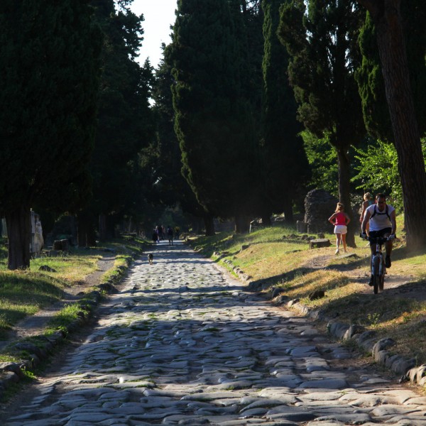 Appian Way (connecting Rome and Brundisium). Modern look.
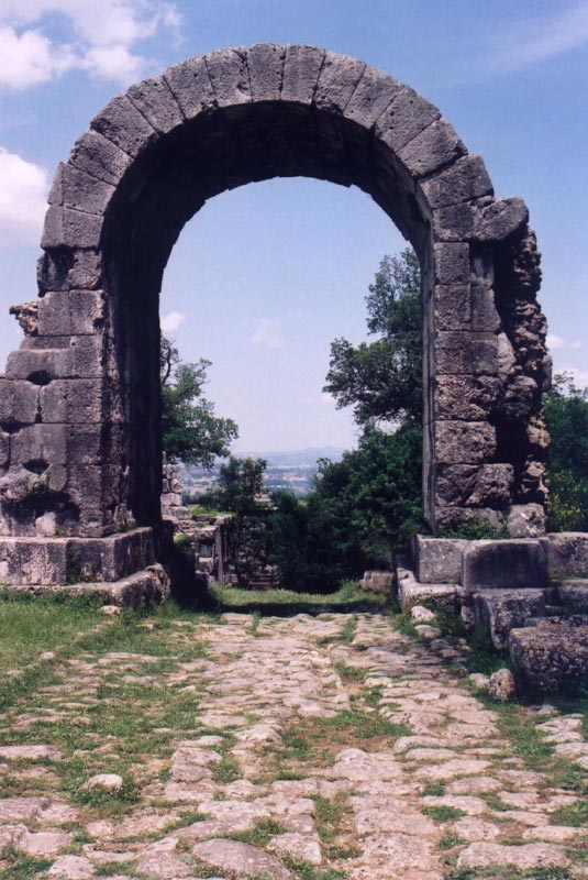 Flaminian Road (connecting Rome and Ariminum). Modern look.
 Emilia Road (connecting Piacenza and Rimini). Modern look.
The Peutinger Table showed that there were 12 roads radiating out from Rome. Those roads led from one city to another and could merge with each other,for instance,the Via Aemilia reached Rimini,and the Via Flaminia led from Rimini to Rome. The well-known proverb “All roads lead to Rome” is true: the Roman forum had a gilded mile stone regarded as the zero point,from which all the principal roads of Italy diverged. That is,whatever road you take,you would end up in Rome. This is the origin of the famous expression.
 Map of Roman roads in the Apennine Peninsula.
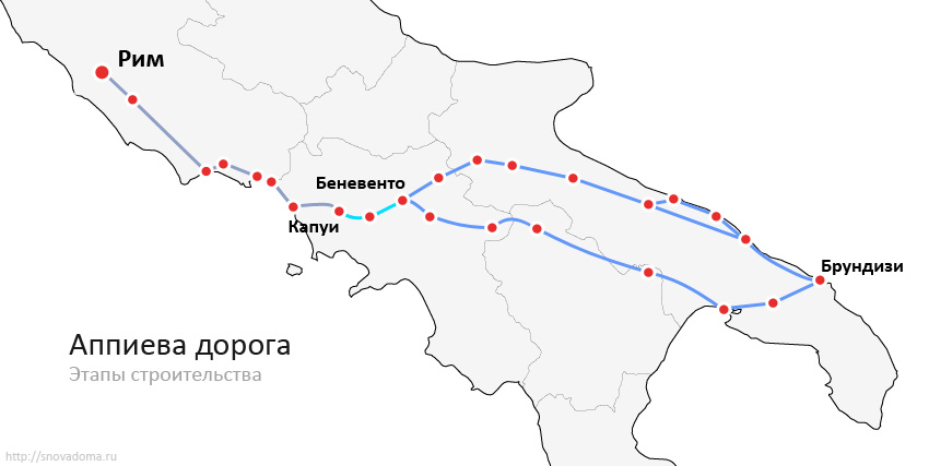 Map of the Apia Road.
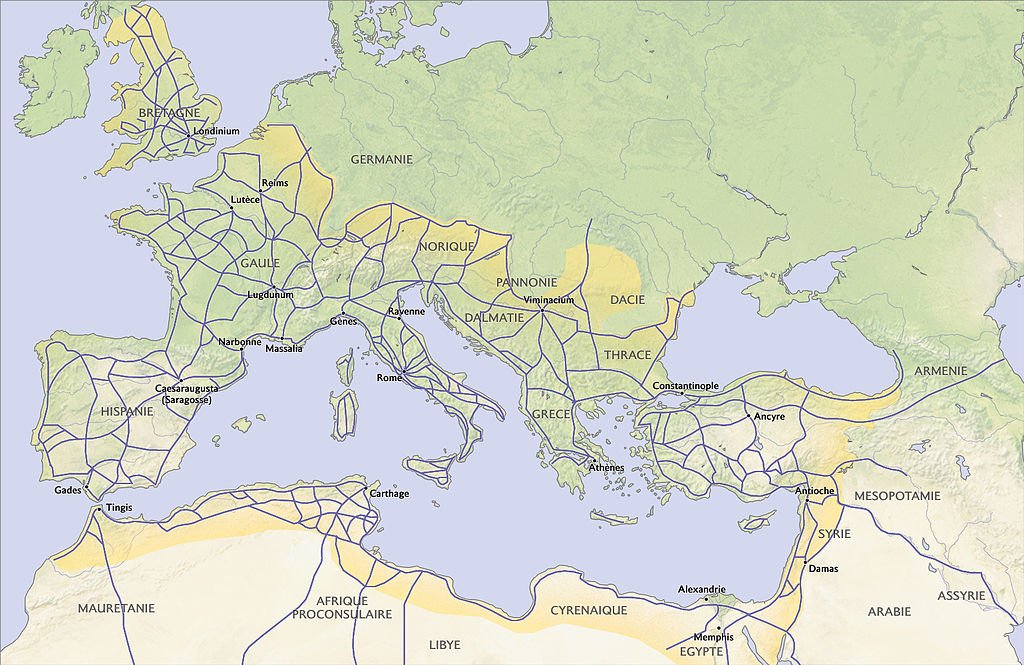 Roads of the Roman Empire.
As far as construction principles of the Roman roads are concerned,V.A. Kochetov described construction works in details,saying that the road was laid with two parallel ropes to fix the width. The surveying was performed by Gromatici – Roman surveyors,who were keen specialists in handling a special instrument – groma (groma is a vertical metal staff with a pointed end for thrusting into the ground and horizontal cross-pieces mounted at right angles on a bracket. Each cross piece had a plumb line hanging vertically at each end). This instrument was used to place poles in a straight line,marking the route of the road. V.A. Kochetov thinks that misalignment of Roman roads in England was no more than ½-¼ mile for every 20-30 miles.
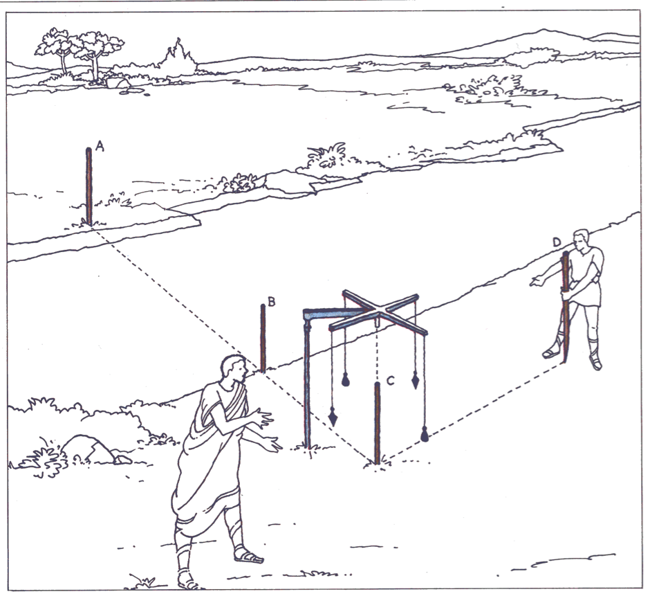 How Gromoy works.
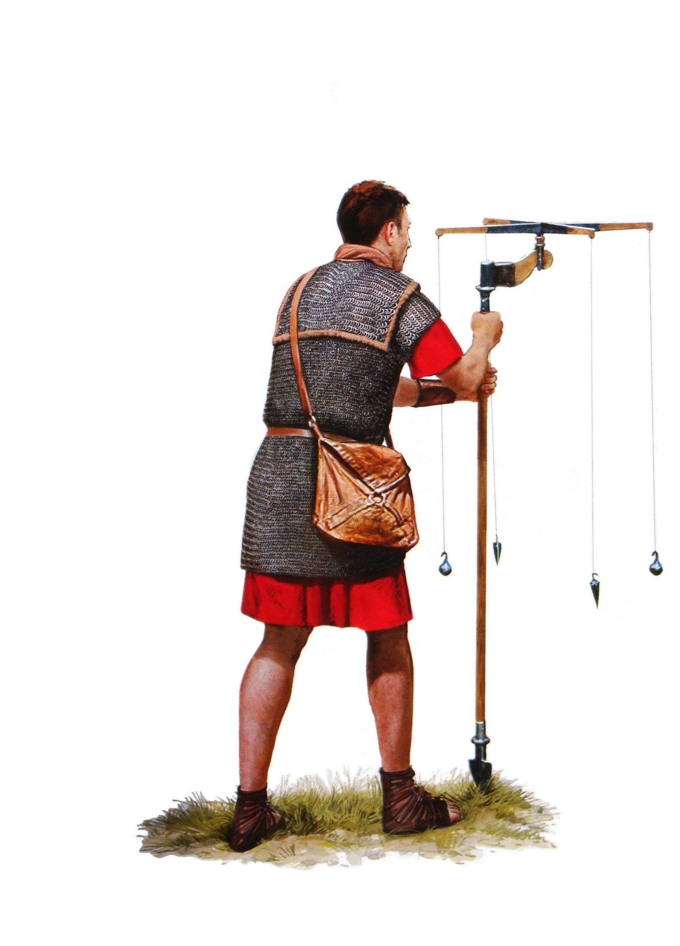 The principle of working with groma.
The Romans strived to make roads as straight as possible,since every turn would mean delay in movement of foot troops. Where the landscape required so,higher grounds were leveled down,gulleys were filled out and bridges were built. Apart from being straight,the Roman roads had another important characteristic: they were durable thanks to many layers and depth. V.A. Kochetov believes that the total depth of Roman roads ranged from 80 cm to 130 cm,with some sections reaching 240 cm. The roads had from four to five layers; middle layers were made of concrete. The bottom foundation layer of many roads was made of stone slabs 20-30 cm thick,which were placed on a well-compacted earth with overlay and then leveled with sand. The middle layer,23 cm thick,was made of concrete (crushed bricks with mortar). The third layer,also 23 cm thick,was made of fine gravel concrete. Both concrete layers were carefully compacted. As far as builders are concerned,usually Roman roads (and many bridges they crossed) were designed by military engineers and built by legionnaires,although in the Imperial epoch many major roads were outsourced to private contractors and built by slaves.
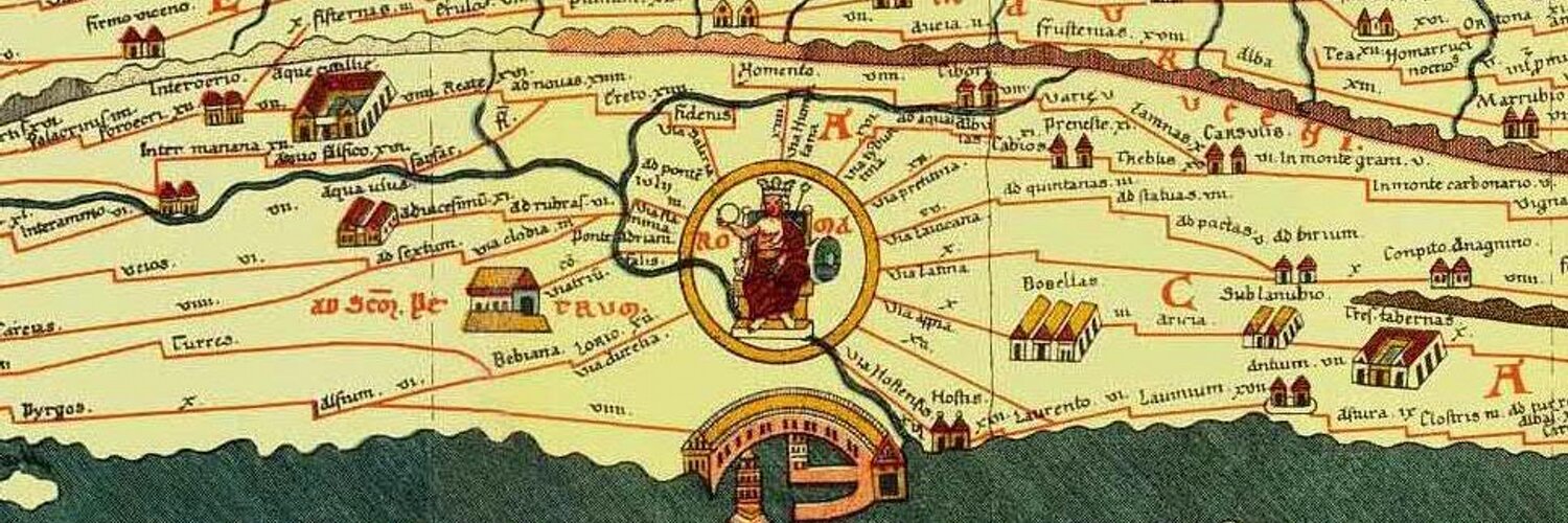 Peutinger's table (Latin: Tabula Peutingeriana). A segment with the image of Rome. A parchment copy of ancient Roman map, which were made by a monk from Colmar (Alsace) in the 13th century. It has in keeping in the Austrian National Library in Hofburg (Vienna).
 The Peytinger table. lat. Tabula Peutingeriana. A segment with the image of the province of Asia. A parchment copy of ancient Roman map, which were made by a monk from Colmar (Alsace) in the 13th century. It has in keeping in the Austrian National Library in Hofburg (Vienna).
It should be pointed out that the Romans were reasonable and pragmatic. Vitruvius said that their rationalism meant wise use of material and space and thrift in building costs. Any antique facilities,be it a temple,a forum or an amphitheater,were mainly constructed with materials derived locally. It made the work easier both for the builders (there was no need to bring material from a distance) and for the customers,who did not pay much for transportation of the materials. G.I. Sokolov states that the Appian Way in its section close to Rome was made of tuff blocks,extracted from a quarry located near Rome and Naples. In the Arrighi valley,197 m of the Way run along the 11 m high wall made of local peperine,with three arched spans for mountain rivers flow. The rest of the Way is built of volcanic lava slabs. All construction materials have volcanic origin; no wonder,since the Vesuvius volcano was located in the vicinity and served the source of all materials. Although construction materials and directions of the roads varied,high quality and long-term service time remained unchanged. On both sides of the road drainage ditches were dug for rainwater,thus,the roads had no puddles. Condition of the roads was carefully controlled and,when necessary,the roads were repaired.
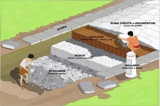 One of the options for laying layers of a Roman road.
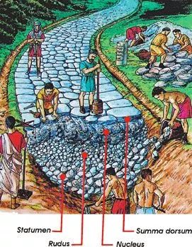 Road construction in ancient Rome.
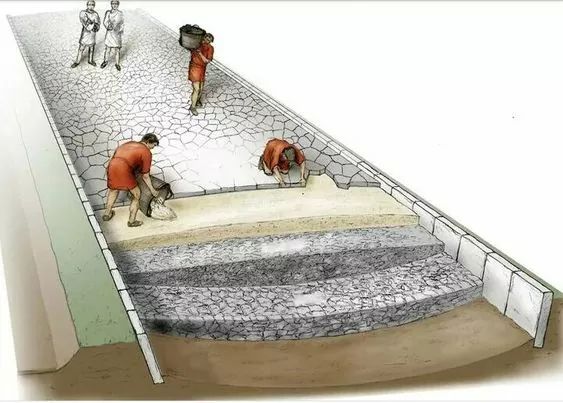 Construction of a Roman road.
This thorough work could not but lead to positive results. L. Thompson states that the troops could cover up to 25 miles a day even in bad weather conditions. Have it in mind that the legionnaires walked in full uniform. When riding horsebacks,as the Imperial Courier Service Cursus Publicus did,it was possible to put on the speed,making 50-60 miles a day,according to L. Thompson. Therefore,urgent messages from the emperor to high-ranking officials and military leaders were delivered instantly. O. Choisy points out that the roads have rest stops with horses changing stations,which also served as inns,due to very few inns around the place,in the guidebooks such stations were named “mansiones”. Also,along the road there were cylindrical mile posts,showing the distance to the nearest settlement and the name of the emperor under which the road was built or was repaired. All these things promoted the travel speed.
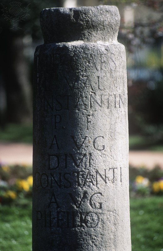 Roman milestone. I BC., Rhone-Alpes region, France.
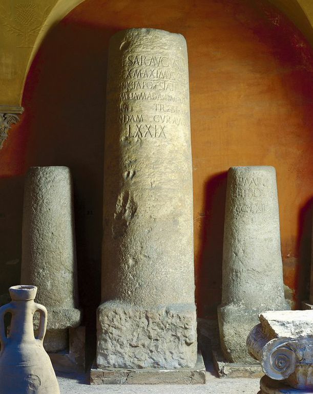 Roman milestone, Aemilius Road, II century BC
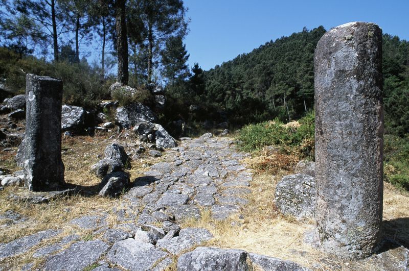 Roman road and milestone. Portela. Peneda Geres National Park (Parque Nacional da Peneda-Geres), Portugal.
T. Mommsen wrote: “Following Claudius,the Roman Senate covered Italy with a network of roads and fortresses... without them military hegemony could not have survived”. The roads ensured control over vast territories,contributed to Romanization of the provinces and developed economy.
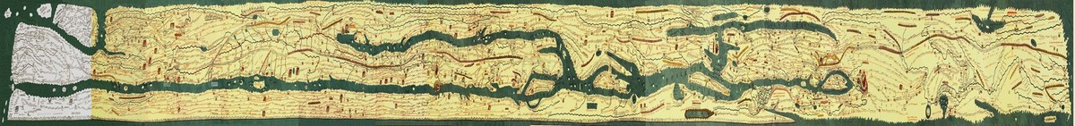 The Peytinger table. lat. Tabula Peutingeriana. A parchment copy of ancient Roman map, which were made by a monk from Colmar (Alsace) in the 13th century. The map is 6.75 m long and 0.34 m wide.It has in keeping in the Austrian National Library in Hofburg (Vienna).
Literature
1) ROMAN ROADS CONSTRUCTION TECHNOLOGY AND USE IN REGIONS DURING THE REPUBLIC AND EARLY EMPIRE. pdf 2) Life of the Greeks and Romans-Velishsky.pdf 3) Vitruvius. X books of Architecture / translated from Latin by F. A. Petrovsky,Moscow: Librocom,2012,317 p. 4) Horace Quint. Satires. [electronic resource]. URL: http://e-libra.ru/read/87549-satiry.html (accessed: 15.01.2017). 5) Roads in ancient Rome. [electronic resource]. URL: http://www.historie.ru/civilizacii/rimskaya-imperiya/96-dorogi-v-drevnem-rime.html (дата обращения: 15.01.2017). 6) Kochetov V. A. Roman concrete,Moscow: Stroyizdat Publ.,1991. 7) Kucherenko L. P. Appius Claudius Caecus: personality and politician in the context of Roman era. Syktyvkar: IPO Syktyvkar State University,2008. 8)Roman censors and urban planning in Italy-Kucherenko. pdf 9) Mommsen T. The History of Rome: in 3 volumes St. Petersburg: Juventa,Nauka,1994. Vol. 1. 10) Letters of Marcus Tullius Cicero to Atticus,relatives,brother Quintus,M. Brutus. [electronic resource]. URL: http://ancientrome.ru/antlitr/t.htm?a=1345960000 (accessed: 15.01.2017). 11) The Letters of Pliny the Younger. Panegyric to Trajan. [electronic resource]. URL: http://librebook.ru/pisma_pliniia_mladshego__panegirik_traianu (дата обращения 15.01.2017). 12) Modern map of Great Britain. [electronic resource]. URL: https://yandex.ru/maps/?ll=0.602518%2C51.173805&z=9 (accessed 15.01.2017). 13) Sokolov G. I. Roman ancient art. [The Art of ancient Rome]. Series: "Essays on the history and theory of fine arts",Moscow: Iskusstvo Publ.,1971,232 p. 14) Titus Livy. The history of Rome from the foundation of the city. [electronic resource]. URL: http://ancientrome.ru/antlitr/t.htm?a=1364000100 (accessed 15.01.2017). 15) Chrestomathy of history of slate and law. Moscow: Norma,2010,vol. 1. 16) Shirokova N. S. Roman Britain: Essays on the history of Historical and Cultural Monuments. [Roman Britain: essays on History and Culture]. Saint Petersburg: Humanitarian Academy Publ.,2016. 17) Choisy O. History of Architecture [History of Architecture],translated from French by V. D. Blavatsky,Moscow: V. Shevchuk,2005,vol. 1. 18) The Roads of Roman Italy Mobility-Ray Laurence.pdf 19) Tabula peutingeriana. [electronic resource]. URL: http://www.tabula-peutingeriana.de/ (accessed 15.01.2017). 20) Thompson L. Roman roads // History Today. Feb 1997. Vol 47. Issue 2. P. 21-28.
Interested in Ancient Rome beyond reading? Join Legio X Fretensis or explore our reenactment directions.


